Malbork
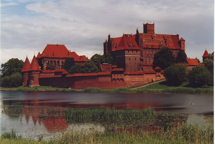
The castle in Malbork.
Distance
Population
38.179 (2009)
Location and history
The town of Malbork is located in the easternmost part of the Pomeranian county, southeast of Gdańsk and southwest of Elbląg. The city is located on the river Nogat. This river is part of the great river Wisła’s participate in the sense that Wisła at the village of Biała Góra southwest of Malbork divides into a left (western) and a right (eastern) branch. The eastern branch or river arm is called Nogat. This river embankment runs through the town of Malbork and continues to the northeast, where it has expired in the Zalew Wiślany (Wisła fjord), from which there is again an outlet to the Baltic Sea. During its run through the northern part of the Malbork urban area, the river bends to the east. The town of Malbork is on the river's right (eastern) bank, ie. the old town, the castle and most suburbs. On the western river bank are some residential neighborhoods as well as an industrial district. Since the Middle Ages, the city has mainly spread to the south; however, there are also some suburbs east of the old town. The urban area of Malbork is on all sides surrounded by colonial gardens; To the northeast is also a large park (Park Miejski). Immediately south of the old town is a road bridge over Nogat with a west / northwest road to Tczew and Gdańsk. At the crusader castle there is a walkway across the river. Just north of the castle area, a railway bridge leads across the river – with train connections northwest to Gdańsk and northeast to Elbląg. The city's major tourist attraction, the former crusader castle, is built directly by the river.
The rise of the city is inextricably linked with the Order of the Crusader and the special state society created by the Order.
The crusader state emerged on the land of the Prussian tribes. The Prussians did not have an actual state formation. Society was thus based on tribes and families.
By the end of the 10th year. the Prussian neighbors, Poland and Russia, already had their own states and central authorities. The Prussians, on the one hand, posed a threat to the borders of the new states and, on the other, were an interesting target for conquest. However, fighting this people, who linguistically separated themselves from the Slavic Poles and Russians, was not an easy task because the dense primeval forests and extensive swamps in their territory constituted a natural defense.
The Polish trials in the period up to the 13th century. to gain influence of the Prussians through the introduction of Christianity did not yield. At the beginning of the 13th century. the Cistercian monk Christian undertook a papal-backed mission aimed at Christianizing the Prussians with the help of knights of order. This goal was to be achieved by an armed conquest of the Prussian lands and the establishment of an ecclesiastical state.
This initiative was an obstacle to future Polish influence in the Prussian area.
However, the Polish prince, Konrad Mazowiecki, also undertook activities on his own that aimed to Christianize the Prussians and promote the political influence of the Poles in the area. In this case, Konrad found an ally in a knight's order originally created to protect pilgrims traveling to the Holy Land. This Order, Order of the Ritter of the Hospital St. Marien des deutschen Hauses, usually called the Order of the Crusaders after the crusade worn by the Order Knights on their robes, settled upon the invitation of Konrad on a land which he had assigned to them, namely the Chełmno area. The knights who came from Thuringia, where they had their property, were the German Emperor Friedrich II’s subjects. In the year 1226, immediately after concluding the agreement with Konrad, they secretly addressed the emperor and were granted a privilege granting the Grand Master of the Order the rights and authority as a prince during the Empire.
This meant that from the beginning the Crusaders intended to create their own state of order.
Already after a few years the Crusaders were successful in the defeat of the Prussians. Although in the first years of the campaign against the Prussians mainly knights from Mazowsze, Kujawy and Pomerania participated, this followed a rapid influx of German knights. In 1234, the pope determined that the lands conquered by the Crusaders were “Saint Peter's property”. In 1244, the pope created four dioceses and divided the land so that the Order of the Crusaders got two thirds and the bishops the rest.
The defeat of the Prussians with the cross – but first of all with the sword, lasted approx. 50 years. Settlers arrived in the depopulated areas primarily from Germany, but later also from the Netherlands and from Poland: Kujawy, Mazowsze and Podlasie.
During this period, the solidly walled and fortified castles, crusader castles as well as church castles emerged.
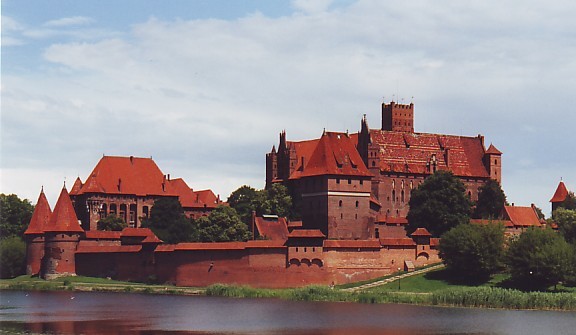
The former crusader castle in Malbork as seen from the southwest – across the Nogat River. To the right is the main square of the capital “Dane”-the tower in the foreground. To the left are the round gate towers at the Bro Gate and the Grand Master's Palace (middle castle).
The town of Malbork was founded just south of the castle, along the river. In the old town you can still see part of the city wall, two city gates and St. John's Church. The city and the castle were connected to each other by defense works and in their time formed a total fortress. Remarkably, however, it is here that the area of the original medieval town, bounded by defenses and city gates, was actually smaller than the area of the castle. The city gained market town rights in 1286, issued by the then comurt of the castle, Konrad von Thierberg the Younger. However, neither this document nor an earlier one that was supposedly issued in 1276 has been preserved. It is, on the other hand, a document from 1304 confirming the privileges previously granted. The river and the surrounding land had an influence on the shape of the city, which was elongated in the north-south direction. That's why the town didn't get the classic square square either. Instead, a street, in German called “Market place”, like the town square. By this street – approx. 300 m long but only approx. 30 meters wide – there was (from the 14th century) the parish church and the town hall. On both sides of this square street houses were built with archways, a style of construction brought about by the immigrants from Silesia, whom the Crusaders had urged to settle in the city. The archways worked, among other things. such as trade passage.
The defense plant around the city was first of earth and wood, but from the 14th century. brick. In this wall were a number of three-sided brick towers (ie open towards the city). There were four gates in the wall. To the south, the city was particularly well fortified, with four walls, one earthen wall and two moat. Of the city gates, the Maria Gate (to the south – later called the Sztum Gate) was particularly important, both architecturally and defensively. It consisted of a multi-storey gate tower and a long porch building located between the middle and outer walls. A similar appearance had the Holy Spirit Gate, also called the Pottemaker Gate – in an easterly direction. In the direction of the castle, the city was only protected by a low wall, which allowed the crusaders on the castle to check what was happening in the city.
In the square as well as in the few side streets stood residential houses as well as stalls, workshops and warehouses. Outside the city walls were breweries, mills and hospitals, as well as the gardens of the citizen and the monastery and finally the agricultural buildings of the order. Around these buildings and businesses the later suburbs were formed. The city was governed by a city council that consisted of 7-8 members with the mayor in the lead. To this was added a barter. However, the supreme power lay in the hands of the Crusader Order.
The city developed especially from the beginning of the 14th century, ie. after the headquarters of the Crusader Order had moved to Malbork.
In connection with the siege of the castle by the Polish forces in 1410 (where it failed to conquer), much of the city burned; the homeless inhabitants were allowed to stay in the prehistory. However, the city was rebuilt and the destroyed defenses repaired. During the 13-year war (1454-66), the city also suffered greatly. After the second peace settlement in Toruń in 1466, Malbork and part of the order's territory came under Polish rule. After this time, the city came back on foot, among other things. by trade in grain and wood. The Swedish wars went hard over Malbork. A new recovery occurred only after 1772, when the city came under Prussia. Troops from the Prussian army arrived in Malbork on September 12, 1772. According to a new census, the population at that time was 3,635. The former city government was replaced by a magistrate, appointed by the Prussian king, as well as a court.
The Napoleonic wars meant forced accommodation of soldiers and plain looting. Incidentally, Napoleon lived at one time in Malbork.
After 1870, several industrial and municipal companies emerged in the city, such as a cigar factory, a mill, a sugar factory, a factory for agricultural machinery, a gas plant, a telegraph, a post office, a telephone exchange and a hydroelectric plant. Malbork became an educational city with several school forms: primary, middle school, vocational school, high school, agricultural school and others. The city developed to the south, in addition to the former Sztum suburb, but also to the east, in the direction of the railway station. Buildings such as Wielbark (to the south), Piaski (to the east) and Kałdowo (to the west) were incorporated into the urban area.
In a post-World War II referendum, in 1920, a large majority voted for affiliation with Germany.
In 1920’A large industrial district emerged in the suburb of Piaski. A river port was also built here. Near the harbor emerged in 1920’There are several companies: sawmill, dry milk factory, cardboard factory and a rubber factory. In the years 1928-37, Malbork, through the organization of a theater festival, sought to interest the tourists for something other than the castle, ie. the city's other attractions.
The influx of tourists was also of great importance to the city's economy before the Second World War. There were many hotels and boarding houses, and on almost every street you could find at least one cafe, patisserie or beer room.
Malbork was severely damaged during the war in 1945. When the Germans withdrew from the castle, they blew the bridges over Nogat on March 8. Ca. 80% of the old town was damaged or destroyed. In April, Polish authorities took over the city.
In the late 1940s’The ruins of large parts of the old city were completely demolished and the bricks were used for the reconstruction of Warsaw. Instead, many apartment blocks were built in that style, so that the inner city is now a mixture of old and new. However, the population grew sharply: In 1946 it was approx. 10,000, in 1994 it was about 40,000. In 1947, a new railroad bridge was built across the river. In December 1949, the new road bridge over Nogat was taken into use. A new thoroughfare, Aleje Rodła, was built across the city center as part of the east-west pedestrian highway. Already in May 1945, work on the malt factory was resumed and from June the district's machine station again functioned. From the beginning of September 1945, teaching was resumed in middle school and high school. In 1946 production at the sugar factory resumed. In parts of a former barracks building, a pasta factory was started in 1962, which over time became the largest of its kind in Poland, producing 25% of the country's total production of pasta.
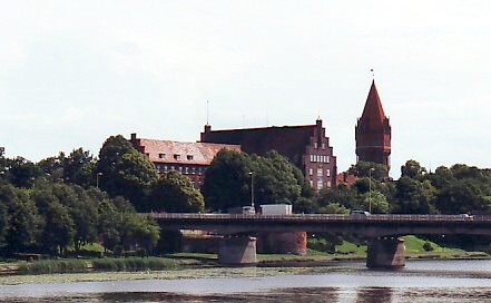
Malbork. From Nogat’on the left bank of the river you look across the road bridge of the municipal administration building and to the right of this city's water tower (built 1905)
Tourist attractions
Castles in the Middle Ages
In the Middle Ages life was in many ways uncertain, and, if possible, one had to secure himself, his family and possessions in the best possible way. Major landowners, among the peasantry, nobility, knights, princes, bishops, kings, and the emerging cities, built protection systems to defend against robbery attacks and attacks and siege by domestic as well as foreign army forces. The first plants were off “reception and bailey” the type, typically a natural or artificial castle bank with a wooden defense tower surrounded by a palisade earthenware (motto). On the lower area below were located operating buildings such as stables, barns etc. (bailey). The later and more future-proofed castle construction consisted of stone-built castles surrounded by a ring wall (or more). Such a castle is typically shared in the main castle, possibly (but far from always) a middle castle as well as (always) a castle. The main castle was the most central and best secured area with a central tower (core tower or bar peace, Fr.:donjon, eng.:keep) for defense purposes and housing for the citizen, and sometimes a building exclusively for housing and representation purposes, a so-called palatium (of which words in European languages such as: palace, pałac, palace, etc.). The main castle was the residence of the citizen, his family and his bodyguard (who also had to serve the capital's defense facilities). The main castle was surrounded by its own ring wall. The middle castle (which, among other things, appears in the Crusader Order's castle building) could have been built as an extension of the main castle or enclosed. The access from here to the main castle could be a drawbridge. The precinct contained housing for servants and caretakers / mercenaries and especially stables and barns, etc. economy buildings. It could be built in extension of (at the foot of) the main castle or completely or partially enclose it. The precinct had its own ring wall (or violence). There could also be two hidden ones. The entire plant was surrounded by a water-filled moat, as needed. supplemented by a dry moat. There could also be a special moat around the main castle.
Crusader Castle Malbork
The crusader castle Malbork (in German: Marienburg) is one of the most outstanding examples of medieval Gothic defense architecture and was the largest fortress built in brick in medieval Europe. The castle (really a fortified monastery) was erected on the right bank, in a place where the river flows from south to north, and down to the water. At the far south is the main castle (13th century). Together with the main castle, to the north, we find the middle castle (14th century), which is erected on the former hidden place. At the far north is the new frontage (14-15th century). In the main castle, the buildings form a square enclosing an inner courtyard; in the middle castle there is also an inner courtyard, but only 3 wings. In the pre-settlement the settlement is more scattered.
The first construction work on the oldest part of the castle began approx. 1276, led by an organization group from the monastery consisting of 12 knights and 6 monks.
In the main courtyard, the inner courtyard is surrounded by pillars in 2 floors. In the northeast corner stands an approx. 40 meter high defense and observation tower. To the southwest corner of the capital's building square is an exterior corridor building, ending with a sanitary and defense tower, a so-called Dane (or Danzer, Polish: Gdanisko; the word possibly derived from the city name Gdańsk, in German: Danzig, or perhaps derived from a Prussian word for damp); here was the largest toilet of the castle, which was emptied into the moat; such an extended tower was often found in the crusades' castle. Access to the urban area was also controlled from the Dane tower. In the north wing, on the first floor, were the two main rooms in the main castle, the Virgin Mary's Chapel and the chapel. The west wing contained a kitchen and a bakery on the ground floor; On the first floor there were apartments for senior persons. In the south wing were bedrooms and dining room and living room. In the basements and attics there were magazines for weapons and ammunition as well as food storage rooms. On top of the ring wall was a weight corridor, which together with the central tower and corner towers formed an effective defense system. Just outside the northeast corner of the building square, ie. Outside the Chapel of St. Anna, a defense tower was erected that guarded access to the entire facility. The entrance from the middle castle to the main castle crosses a wind bridge. In the middle of the courtyard is an 18-meter-deep well, most importantly not least in the event of a siege where water supply was crucial. The plant was surrounded by a double wall, against the middle castle, however, only a single wall. The area between the walls east of the plant contained, among other things. a cemetery for the Order Knights.
In the original castle facility, there was a courtyard directly north of the main castle with stables, wagon gates, warehouses, workshops and housing for servants. There was also a mill building on the grounds of the castle. Construction of the castle was initially completed around the year 1300. Some years later, after 1309, when it was decided to move the headquarters of the Order – and thus the residence of the Grand Master – from Venice to Malbork, an extension was needed. The three wings, which became hereafter known as the middle castle, were erected in the place of the original hideaway. Further north, a new fort was built.
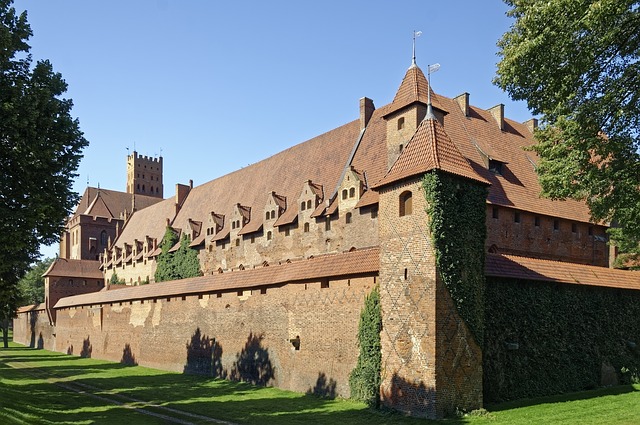
The southeastern (eastern) wing of the middle castle, which among other things, contained rooms for guests of the order. – Picture of 680451 from Pixabay
In the middle of the castle, the main building is the residence palace for the head of the order: the Grand Master. This mansion is built with the west wing at an angle, so that the mansion's one facade faces south, while a slightly shorter east facade continues in the west wing's east facade. The West Wing also contains the large dining room, the largest representation room in the entire castle. To the north stands the gate building with the gate leading out to the front door. In the gate building, west of the gate, was the infirmary (ie the hospital). In the same building, there was a residence for the Grand Comforter (Grand Master's Deputy). On the east side of the inner courtyard there were guest rooms. The fact that there was no south wing in the middle castle made it possible to observe from the main castle what was going on in the middle castle. In the gate leading from the concourse to the middle castle there are 3 security devices to stop attackers who may have entered the concealment, namely a wind bridge, then a drop grid with a gate corridor and finally a new drop grid and a slate. In total, an outsider who wanted to enter the main castle had to climb no less than 14 gates, 4 wind bridges and 3 parachutes. The middle castle was to the north and east surrounded by an extra wall.
The new precinct – like the former – contained economy buildings and housing for servants. In the eastern part of the plant stood a ground-walled building, called Karwan, where carts, weapons and ammunition were stored. West of this building stood a number of horse stables. In the western part was built a long chain of buildings which included bakery, hospital, painting, brewery, warehouses, housing for servants, hen houses, pig stables, costumes etc. At the end of this chain of buildings stood (and stands) a church, Church of Saint Laurent (Kościół św.Wawrzyńca). All of these buildings were surrounded by a special ring wall, reinforced by five brick towers. The wall was connected to the defense walls around the main and middle castles. In the northwest corner of the fort's fortification was built around 1335 a characteristic round defense tower, later called Wieża Maślankowa (Buttermilk Tower). The tower has a height of 28.8 m and a diameter of almost 9 m. This defense or guard tower also served as a prison. (The name is associated with a legend about farmers from the village of Lichnowy, who in his time was supposed to deliver buttermilk to the castle).
Access to the concourse was through two gates. One consisted of the east side gate with two fortified entrances and gates separated by a smaller courtyard. The second gate led in from the west side, via the gate with the characteristic cylindrical gate towers and between the defensive walls to a gate system in the northwest of the prairie. This west gate – called the Bro Gate (Brama Mostowa) – with a gate tower on each side of a two-part access gate, was formerly part of a larger facility, with access to the gate initially leading via a bridge across the river; On the left bank of the river one entered the bridge via an access between two bridge towers – also round. Only the Broporten remains of this plant.
In the years 1331-44, an internal rebuilding took place in the north wing of the main castle, as the chapel was rebuilt and the Virgin Mary's Chapel expanded eastward, creating a new chapel, St. Anna's Chapel, which was later used as a burial chapel for the Order's Stormers. The last building, under the direction of the Crusader Order, which extended the total area of the castle to nearly 20 ha, was an extension of the eastern line of defense; this happened after the Polish king, Władysław Jagiełło, had besieged the castle in 1410.
A moat was found on the east and north sides of the main and middle castles. Within this there was also a dry moat on the west, south and east sides of the main castle. The front yard was also surrounded by a moat.
To obtain water to fill the trenches, a canal had been dug during the building of the castle from the lake Dąbrówka south of Malbork.
Malbork was the capital of the Order of the Crusaders from 1309 to 1457. From 1457-1772, the castle was on Polish hands and was the seat of the local Starosta as well as the residence of Polish kings.
Many Polish monarchs stayed here, as follows: Kazimierz Jagiellończyk (1457), Jan Olbracht (1494), Aleksander (1504), Zygmunt I (1526) and Zygmunt August (1552) and others; also several Swedish kings as well as Napoleon I Bonaparte of France and Peter the Great of Russia.
In the years 1626-29, Malbork was occupied by the Swedish army, which further fortified the castle in the form of eleven earth bastions. In 1656 the Swedes re-invaded Malbork and left it only after the peace settlement in Oliwa in 1660.
The castle was damaged several times in the 19th century. After 1882 it was systematically rebuilt under the direction of engineer Konrad Steinbrecht.
During World War II, the castle of Malbork was severely destroyed. After the war, the ruined building was rebuilt, renovated or reconstructed. In 1965, the impressive exhibition of amber was opened, which in the years to come also helped to attract tourists.
The buildings can now be viewed entirely by tourists. Malbork is (from 1997) admitted to UNESCO’World Heritage List; the grounds for admission here are partly the castle as a symbol of the Crusader Order's power position in the time, partly the castle's excellent architectural values, and partly the castle as an example of excellent conservation and renovation work.
At the castle there are many exhibitions, including with amber, armor, weapons, archaeological finds, etc. All visits take place in groups led by a guide. All the main rooms and buildings in the main and middle castles are visited.
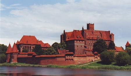
The Crusader Castle in Malbork
Old Town City Hall
The seat of the medieval city government was located in the eastern row of houses on the square. In its present form, the building was erected in the second half of the 14th century, c.1380. Several demolitions of the town hall in connection with sieges of the castle and the city were followed by reconstructions, especially in the 15th century. In the 19th century. necessary preservation work was done on the facade of the building, repairing broken parts of decorations in the form of sling bands. A new renovation, especially of the roof construction, took place after a fire in 1899. The mayor and city council stayed in this house until 1929, when the new town hall was put into operation. This new town hall building is also today the seat of the municipal administration.
After 1929, police were housed in the building. Today, the old town hall building is the seat of the Youth Culture House.
St. John's Church (Kościół św.Jana)
In the old town there has been since the end of the 13th century. been a parish church consecrated to John the Baptist. The church, which throughout its history has belonged to the Catholic congregation, was rebuilt several times, both in the Middle Ages and in recent times. The present architectural form is mainly due to a reconstruction around 1468, where the church rose from the ruins after the 13-year war. The building is the wooden ship with a tower to the south.
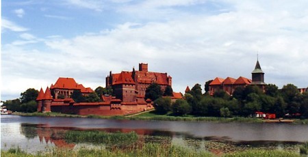
Malbork. From Nogat’On the left bank of the river you will see St. John's Church to the right of the castle area
St. Jørgen's Church (Kościół św.Jerzego, now: Kościół MBNP)
The first mention of the church dates from 1403. In 1470’The church was rebuilt after the destruction of the 13-year war. In 1598, St. Jørgen's Church was entrusted to the Lutheran congregation in the city. The church was again badly damaged during the Swedes' attack in 1658. The current appearance of the building dates from the years 1712-14. In the church is the baptismal font from the time of the old church, while other equipment is newer, thus the pulpit from 1713-14 and the main altar from ca. 1718. In the cemetery the conservator of the castle, Konrad Steinbrecht (1849-1923) is buried.
Maria port (Brama Mariacka – also called the Sztum Gate)
The old town of Malbork already got in the 13th century. a defense facility that was later expanded and improved. Of the medieval plant, part of the city wall to the east is preserved as well as to the west a support wall up to the higher urban area; this wall was previously built with various warehouses. Furthermore, today two of the city gates can be seen, one of which is the Mary Gate, through which there was access to the city from the south. The gate was built in 1320-1330 with a floor plan of 6.5 × 7.5 m and a height of 10 m. In 1945 the gate burned down. At the 1964 reconstruction, the original four-sided roof was not reconstructed. For many years the building stood unused. In 1970’A café was set up in the gate building and later a pub.
Potter port (Brama Garncarska)
The potter's gate (from the 15th century) is the second of the two preserved city gates. This gate created access through the eastern part of the city wall. The five-storey building is made of brick. The roof is covered with roof tiles and has a fall to four sides. The upper part of the building is decorated with pointed arches. During World War II, the tower was severely damaged. When rebuilt in 1955, it was covered with a four-sided roof. For a number of years there was a tailor workshop in the building. The physical condition of the port building is not the best and there is no access for tourists.
Bymuren
Parts of the city wall to the east, the support wall to the west, ruins of brick towers and 2 of the city gates are preserved. (See also above under: The Mary Gate). In the past, there was a deep moat between the castle and the city. The moat and the external defense system were to some extent demolished and leveled in 1839 and since 1878-83.
Former Jerusalem Hospital
The hospitals of the Middle Ages were not just general hospitals in our sense, but specifically aimed at poor people who could not cope with themselves during illness; moreover, they served as nursing homes for old people. The hospitals were maintained by the city government with the help of gifts from the residents. As there was always a danger that epidemics could spread from hospitals to the rest of the city, these institutions were almost always erected outside the city wall.
The preserved hospital building dates from the 16th century. and is in two floors. It was referred to in 1528 as “a hospital for poor people”. There are plans to set up a hospital museum in the building.
The mill at Konopnicka street
A preserved Gothic mill building south of the center. It was originally a mill (for the manufacture of textiles from wool), owned by the city. The mill is mentioned in the sources in 1400. The building is built in bricks whose character and size are typical of Gothic buildings from the 15th century.
Water Sports
The beach at Malbork is open from May to September. Here in the season there is the opportunity to practice different kinds of water sports. You can also sail with smaller excursion boats on the Nogat River.
Surrounding Area
Żuławy
Malbork is sometimes called “the capital of ławuławy”. Ławuławy Wiślane is the term for the land lying between the river Wisła’s main course and its branch Nogat and which extends up to the Baltic Sea. It is a delta area, ie. a flat plain landscape, of which significant parts (28%) are even below sea level. Only 25% of the country is higher than 5 meters above sea level
Accommodation
Booking.com
Malbork – in Polish, English and German – with practical information for tourists
Eating Out:
Malbork – in Polish, English and German – with practical information for tourists
Other Internet sites and sources
Malbork – in Polish, English and German
Other pages about crusader castles:
Crusader castles and bishopric castles in northern Poland
Translated into English by Google Translate. Spangshus.dk accept no liability for any errors or omissions in translation.
Map

Rating
Search
Most used tags
churches (205) Castles (86) Monasteries (79) Town walls (74) Lakes (71) Town halls (67) Rivers (65) Castles1 (62) Mansions (55) Museums (51) Regional museums (38) Town gates (36) Abbey churches (35) Castle ruins (30) Cathedrals (26) Forests (25) Health resorts (24) Water sports (23) Mounds (23) National parks (22)Click for all tags
Denne side er også tilgængelig på dansk. This page and contents is (c) Copyright 2018- www.spangshus.dk. Based on Inviator software by ISCA Software