Lubań
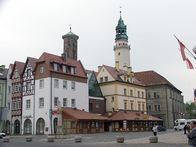
Lubań. The rebuilt, central house block in the square around the Kræmmert tower, seen from the northwest – with the town hall and the town hall tower to the right in the picture
Distance
Population
22.685 (2007)
Location and history
Lubań is located on the river Kwisa, which is a significant tributary of Bóbr, in the Lower Silesian region, ie. southwestern Poland. The city is a short distance from both the German and Czech border with 24 km to Zgorzelec (German border) and 24 km to Zawidów (Czech Republic) (or even shorter to Miłoszów (15 km).
Lubań probably got its market town rights in the first half of the 13th year. Between 1319 and 1337 the town belonged to the Jawor Principality.
During Henry I of Jawor, the city experienced strong economic development. A town hall was also erected, of which a single part, namely the tower, is preserved to our day; it is called “Wieża Kramarska” (Kræmmer tower).
The town center was also in the Middle Ages the square square, from which streets were drawn in straight lines. The four main exit roads passed through the city gates: Brama Zgorzelecka to the west, Brama Bracka to the south, Brama Mikołajska to the east and Brama Nowogrodziecka to the north. At one point, the city was given an autonomous assembly, made up of local councilors with the mayor at the head. The self-governing council met in the town hall in the middle of the square. Around this building came many stalls where artisans and carpenters faltered their wares; it could be bakers, tailors, butchers or dressmakers. Not least, the beer brewery made great progress; the good products from the breweries in the city were known knowledge.
Lubań was granted many useful privileges, thus, by the city's craftsmen organized in guilds, were given a monopoly on supplying the town's hinterland within a mile of goods such as: beer, meat and bread.
Between 1346 and 1621 the city and the area are under Czech rule.
The invasion of the Hussite forces in the city in 1426 and 1431 caused considerable destruction; much of the city burned down. Other accidents also affected the city, such as fires in the 13th, 1300s, 1400s, 1600s, and 1700s, and epidemics, especially in the 1400s-1500s, 1600s and 1800s.
In the years 1539-1543 a new town hall – in the Renaissance style – was erected in the square. In 1588 a high school arose in the city.
In 1635 the town and the area were surrendered to Saxony. In the 18th century, canvas weaving flourished as a craft in the city, not least because of the immigration of Protestant weavers from the Czech Republic.
In 1815, the city was incorporated into Prussia, as part of the province of Lower Silesia.
The first industrial companies emerged in the city in the 19th century, i.a. a ceramic enterprise and a mechanical weaving mill. Lubań specialized in the manufacture of handkerchiefs, which were even exported to several countries. In the second half of the 19th century. the medieval fortifications were partially demolished and the moat was replaced by a promenade.
Between February and May 1945, bitter fighting was fought over the city between German and Soviet forces. Nearly 60% of the city was destroyed. Only on May 9, 1945, was the city finally liberated. After the war, the city and the area came under Polish rule again.
Tourist attractions
Selected attractions:
City Hall (Ratusz)
in the Renaissance style from 1539 on the square. A valuable building memorial created by architect J.Lindner. The tower has a height of 60 and is fitted with a Baroque-style tower helmet. The building now houses the council halls, the regional museum, the National Register and the public library.
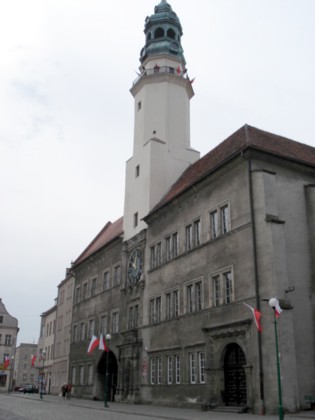
City Hall
Square
Before World War II, there was a collection of old houses in the middle of the square – around “Kræmmer Tower” (Wieża Kramarska), the remaining remnant of the city's first town hall. Due to the acts of war, this building mass was almost completely destroyed, but part of the walls remained. However, the Cremator Tower had been spared, so when the last building remains were demolished in the late 1950s, the tower came to stand alone in the middle of the square for many years. It was not until 1992 that the original peat environment was re-established. In addition to the reconstruction of the square houses around the old town hall tower, the project also included the construction of a central, glass-covered hall.

The central house block on the square as seen from the east
Kræmmer Tower (Wieża Kramarska)
the square is the only remnant of a former town hall. The old town hall burned in 1487.
Bymuren
The original double ring wall of basalt stones dates from about 1331. The stones came from quarries in the city. The wall has a thickness of up to 2.5 m. In the main, the wall was demolished in the 19th century. The best preserved course of the wall can be seen along Podwale Street.
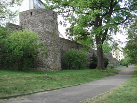
Bymuren
Bracka Tower (Baszta Bracka)
The tower was originally part of the Brama Bracka city gate and is the only preserved part of the city's four city gates. The cylindrical defense tower is built in basalt stone.

Bracka Tower
Trinity Tower (Wieża Trynitarska)
is the preserved bell tower of the old Trinity Church that stood in this place.
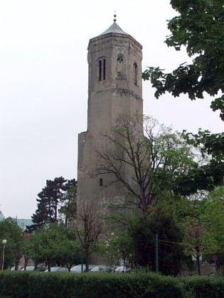
Trinity Tower
salt house (Dom Solny)
also called the Kornhuset, a grain magazine, built on the initiative of the city council in 1539. Built by basalt squares. In the 19th century. served the building as a prison.
Trinity Church (Kościół pw Trójcy Świętej)
The church – in neo-Gothic style – was built in the years 1859-1861 in the northern part of the city, more specifically where the northern city gate, Brama Nowogrodziecka, used to be.
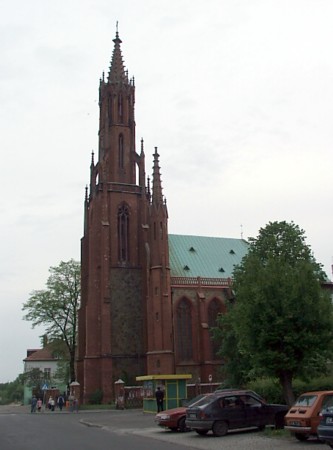
Trinity Church
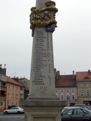
A pillar – “milestone” – erected by the Saxon Post Office in 1725, indicating distances to other cities in German miles
Surrounding Area
In the vicinity of the city one should visit the small town Leśna south of Lubań.
Near Leśna one should definitely visit the medieval castle Castle Czocha .
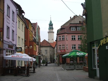
Bracka street seen to the north – towards the town hall. In the Middle Ages, Bracka Street was the direct link between the square and the southern city gate, the Bracka Gate. This is true even today, only from the aforementioned city gate, only the defense tower, the Bracka tower, remains
Accommodation
Booking.com
Miasto Lubań (in Polish, English, German and Czech) – with practical information for tourists
Eating Out:
Miasto Lubań (in Polish, English, German and Czech) – with practical information for tourists
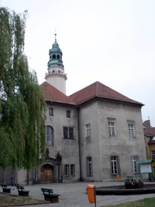
City Hall seen from the southwest
Other Internet sites and sources
Miasto Lubań (in Polish, English, German and Czech)
Translated into English by Google Translate. Spangshus.dk accept no liability for any errors or omissions in translation.
Map

Rating
Search
Most used tags
churches (205) Castles (86) Monasteries (79) Town walls (74) Lakes (71) Town halls (67) Rivers (65) Castles1 (62) Mansions (55) Museums (51) Regional museums (38) Town gates (36) Abbey churches (35) Castle ruins (30) Cathedrals (26) Forests (25) Health resorts (24) Mounds (23) Water sports (23) National parks (22)Click for all tags
Denne side er også tilgængelig på dansk. This page and contents is (c) Copyright 2018- www.spangshus.dk. Based on Inviator software by ISCA Software