Jawor
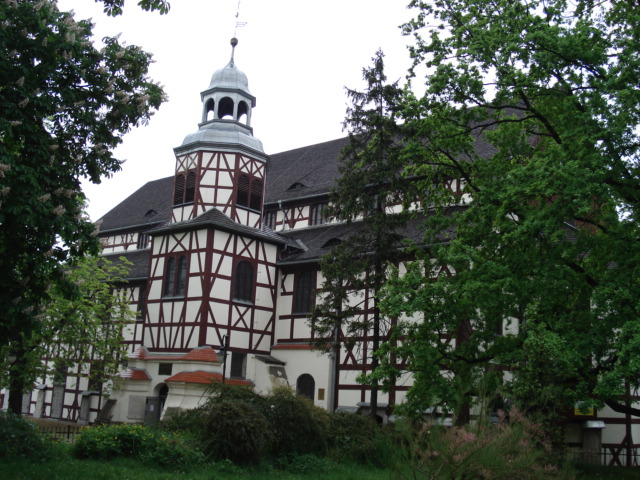
Peace Church (Kościół Pokoju) in Jawor
Distance
Wałbrzych 36 Sun, Wałbrzych 37 Sun, Świebodzice 28 Sun.
Population
26.000 (2006)
Location and history
Jawor is located in southwestern Poland, in the Lower Silesian region, 19 km south of Legnica.
The town of Jawor was granted commercial property rights in the middle of the 13th century. It is known that the city in the early 1280s’the walls were surrounded by a stone-built fort – a city wall. The town developed in the Middle Ages into one of the most significant centers of weaving crafts in Silesia. Jawor was part of an independent Piast Principality and since then became the provincial capital. In 1488 a new monastery for the Order of the Bernardine was inaugurated. In the 16th century. came the Reformation movement and in the 17th century. the clashes between Catholics and Protestants, which caused great havoc in the city. In the 18th century. followed the Silesian wars between Austria and Prussia, and the city then came under Prussia. A fire in 1776 destroyed the city to a great extent. In the 19th century. the first rail links were built; in 1901 the first telephone lines were established and in 1914 the first sewerage works in the city were started. From 1945, Jawor belonged to Poland. The Soviet army had caused considerable destruction, but the city was rebuilt reasonably quickly.
Tourist attractions
Church of Peace (Kościół Pokoju)
is listed in 1654-55; the name refers to the Westphalian peace, ie. the peace treaty that ended the Thirty Years' War in 1648, according to which was to be erected evangelical churches in 3 Silesian cities: Głogów, Jawor and idwidnica. The Jawor church building was designed by an architect from Wrocław, Albrecht von Säbisch. The church, located in a park in the northwest of the city (just outside the Old Town), is a rectangular timber-framed building, completed with a triangular chancel. The interior of the church is Baroque. For centuries, the building has delighted many through its masterful workmanship and rich equipment.
(See photos at the top and bottom of the page).
St. Martin's Church
This is the oldest church in the city. The church (in the northern part of the Old Town) is Gothic and dates from the transition between the 13th and 14th centuries. The church's Baroque-style equipment is at a high artistic level. This applies to epitaphs in the Maria Chapel of the Northern Ship, the image of Saint Martin above the main altar, an Epitaph of the Southern Ship and medieval frescoes on the vaults. The former cemetery around the church is surrounded by a wall of numerous epitaphs.
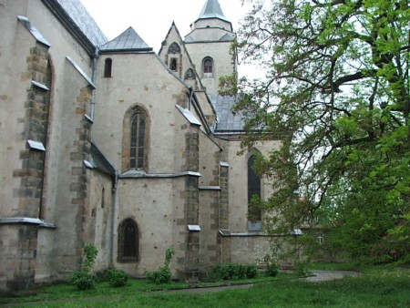
St. Martin's Church
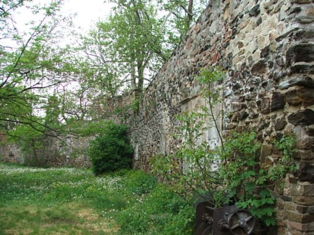
St. Martin's Church. The old cemetery wall
City Hall
The town hall building on the square is first mentioned in 1373. However, the tower has come later; it dates back to 1394. Over time, in addition to the basic function, the building has also served as archive and prison. The Town Hall was rebuilt in 1617 and 1846. In 1895, the Town Hall burned down, leaving only the tower. In 1895-97 (re), the town hall was built almost from the ground up and it now appears in neo-Renaissance style.
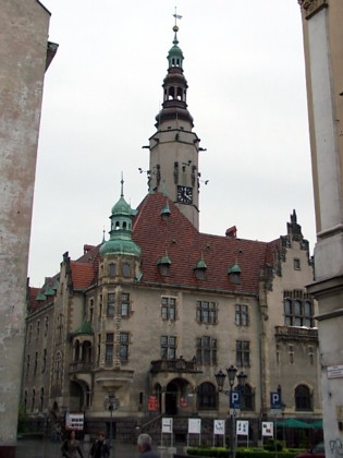
City Hall as seen from the northwest
Townhouses on the square
The rectangular square, measuring 140 × 65 m, is surrounded by courthouses with archways. In the places on the eastern and northern side that were destroyed in 1945, there remained in 1960’the houses erected blocks of flats to replace the original houses. The oldest houses date from the 16th century.

The south side of the square with the (for the whole square) characteristic archways
Borgen
The Piast family castle (in the Old Town southwest of the square) was originally built in the 13th century. as the seat of Prince Bolko I and his successors. After the destruction of the Thirty Years War, the castle was rebuilt by Otto von Nostitz in the form of a modern residence building. Later remodels in the 18th and 19th centuries. however, blurred the original character. Today, the West Wing has retained its Renaissance style, while the Northeast has retained Baroque features. From 1746 to the late 1950s’in the building there were prisons in the building complex. From 1888 to 1945 it was a purely female prison. During World War II, members of the resistance movement in Norway and France were held captive here.
The Franciscan Order Monastery and Church
In 1748, the Order of the Franciscans purchased a plot of land. Żeromski Street. Here the monastery and church were erected. After the closure of the monastery, the building has, over time, housed an evangelical girl's school, library with reading room, preventive facility for pulmonary disease, supply store for the theater and furniture store. Currently, the buildings belong to the Pentecostal church.
Saint Wojciech’s Chapel
Baroque-style, but of medieval origin, is in the Old Town, south of the square. Previously there was a synagogue, which was converted into a church in 1438. After 1446, the building served as a hospital chapel. In 1729 a basic rebuilding took place. In the post-war years, the building served as a baptismal chapel.
regional Gallery
The building complex (in the southern part of the Old Town) consists of the Gothic Virgin Mary's Ascension Church and a monastery. The shrine was consecrated in 1489. Between the middle of the 16th century and the middle of the 17th century, the monastery belonged to the city, which among other things. set up a Protestant school in the building. After the abolition of monks in 1810, the building became state property. After that, it included a military arsenal and a police office. In 1964, the building complex was taken over by the Regional Museum, which carried out a general renovation. In the buildings can still be seen the Gothic frescoes depicting the sufferings of Christ, St. Bernard, Saint Francis’ stigma, The Last Supper and the Fall under the Cross.
Bymuren
The fortification of the city was built at the end of the 13th century, probably at the initiative of Prince Bolko I. Through the wall, four gates entered the city: the Bolków, Legnica, Złotoryja and Strzegom gates (the last reinforced with a gate tower). . In order to withstand the new firearms, the fort was reinforced in the early 16th century with an extra outer wall. The most exposed places were provided with brick towers (fortress towers) from which to fire with both cannons and small arms. Only a few fragments have been preserved to this day. Best preserved is the tower called Zamek Anioła (Angel Castle). Another fragment of a brick tower can be found behind the Social Assistance Office at Plac Seniora. Incidentally, the city wall was demolished during the 19th century.
Strzegom Tower
This medieval gate tower has a square floor plan on the first floor, but goes higher up into an octagonal shape. The tower is 24 meters in height and the walls are up to 1.9 m thick. The building (in the southeast corner of the old town, by ul.Strzegomska) has preserved certain Gothic features, such as the small, pointed arched windows. The tower was built to defend the Strzegom gate found here. The tower later served as an observation tower, prison and gunpowder.
Surrounding Area
Powiat Jaworski Jawor District page
Ziemia Jaworska – in Polish, Czech and German
Accommodation
Booking.com
Ziemia Jaworska – in Polish, English, Czech and German
Eating Out:
Ziemia Jaworska – in Polish, English, Czech and German
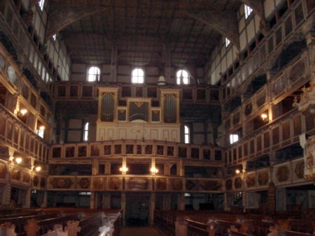
Interior of the Peace Church
Other Internet sites and sources
Jawor The city's official site
Ziemia Jaworska – in Polish, English, Czech and German
Translated into English by Google Translate. Spangshus.dk accept no liability for any errors or omissions in translation.
Map

Rating
Search
Most used tags
churches (205) Castles (86) Monasteries (79) Town walls (74) Lakes (71) Town halls (67) Rivers (65) Castles1 (62) Mansions (55) Museums (51) Regional museums (38) Town gates (36) Abbey churches (35) Castle ruins (30) Cathedrals (26) Forests (25) Health resorts (24) Water sports (23) Mounds (23) National parks (22)Click for all tags
Denne side er også tilgængelig på dansk. This page and contents is (c) Copyright 2018- www.spangshus.dk. Based on Inviator software by ISCA Software