Gryfice

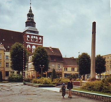
Gryfice. Lot from the square with the Maria church in the background
Distance
Population
16.737 (2006)
Location and history
The town of Gryfice is located in the north of western Pomerania, on the Rega river, coming from the southeast, running through Gryfice and further north through the town of Trzebiatów before it opens into the Baltic Sea.
Gryfice is an old town that gained market town rights in 1262; these privileges – including the right to sail with goods on Rega – were granted to the city by Prince Warcisław III. Goods transport soon took place across the entire navigable stretch of the river and all the way to the sea. But the Trzebiatow City Council wanted to get their share of this source of revenue and this battle lasted for many years. Despite the conflict between the two cities, Gryfice developed as a city in the Middle Ages; they lived from agriculture, crafts and trade – not least grain trade. The city was first surrounded by an earthquake with a moat, since – in the 14th century. – of a defense wall of natural stone and brick. Some parts of this wall can still be seen today. Gryfice was a member of the Hanse Association. The 30-year war in the 17th century and its consequences were devastating for the city and trade and crafts almost stopped. It was not until the following century that the economy improved significantly. In 1882 the rail link to Szczecin and Kołobrzeg came, and in the following decades a number of narrow-gauge railroads were built to localities in the vicinity. At the beginning of the 20th century. a wide range of industrial companies were opened, such as a sugar factory, a lime kiln and companies in other product areas such as ceramics, ovens, potato flour and jam. Gryfice became a well-developed, local center for industry and commerce.
Tourist attractions
railway Museum
An exhibition of railway equipment for narrow-gauge railways in western Pomerania.
Brama Kamienna (Stenporten)
formerly called the Mill Gate, is the northern city gate on the road to Trzebiatów. The gate is mentioned since 1333.
Brama Wysoka (The High Gate)
was also part of the medieval defenses of the medieval city; it stood – and stands – by the city's exit road to the south, dividing into the roads towards Kamień Pomorski, Stargard, Nowogard and Szczecin. The gate already existed in the year 1300. Brama Wysoka has a pointed arched doorway and consists of 3 floors. The building now houses a gallery and museum. – In the past, Gryfice had 3 city gates: in addition to the aforementioned Brama Kamienna and Brama Wysoka, also Brama Reska (the Rega gate) by the road towards Kołobrzeg and Koszalin, ie. to the northeast.
Baszta Prochowa (Powder Tower)
This tower was located in the northeast corner of the former fortifications, near the River Rega, and served as a shooting tower. It was built in the 15th century. in Gothic style, stone walled, covered with gothic bricks. The powder tower is built in the form of two cylinders, one around the other.
Kaplica Świętego Jerzego (St. George's Chapel)
lies within the cemetery wall; it now functions as a cemetery chapel. Originally, it was attached to the hospital that existed at this place since 1337. It was then the prayer room for the hospital's patients and staff.
Kościól Mariacki (Church of Mary)
The church was built in the Gothic style during the transition between the 13th and 14th centuries. First the choir arose with the sacristy on the south side; since the main ship and eventually the tower, probably in the 15th year. Until 1534, the church was a Catholic church; afterwards it was taken over by the Lutheran congregation before it was later re-Catholic.
The city wall and the fortifications
Construction of the city wall began at the end of the 13th century. and continued in the 14th century. In the 19th century, when the medieval fortifications had long been unnecessary, demolition began. Of the original plant, today only two urban gates are found, the Powder Tower and the remains of the city wall. In 2007, parts of the remaining remains of the city wall were rebuilt.
Surrounding Area
Gryfice is the center city of a district that extends all the way to the Baltic Sea.
See our pages about the following cities and other localities in the area: Trzebiatów , Niechorze , Pogorzelica , Mrzeżyno .
About the town of Płoty follow this link: Płoty
Accommodation
Booking.com
Gryfice. The municipality's official site with practical information for tourists
Other Internet sites and sources
Gryfice. The official site of the municipality
Translated into English by Google Translate. Spangshus.dk accept no liability for any errors or omissions in translation.
Map

Rating
Search
Most used tags
churches (205) Castles (86) Monasteries (79) Town walls (74) Lakes (71) Town halls (67) Rivers (65) Castles1 (62) Mansions (55) Museums (51) Regional museums (38) Town gates (36) Abbey churches (35) Castle ruins (30) Cathedrals (26) Forests (25) Health resorts (24) Mounds (23) Water sports (23) National parks (22)Click for all tags
Denne side er også tilgængelig på dansk. This page and contents is (c) Copyright 2018- www.spangshus.dk. Based on Inviator software by ISCA Software